
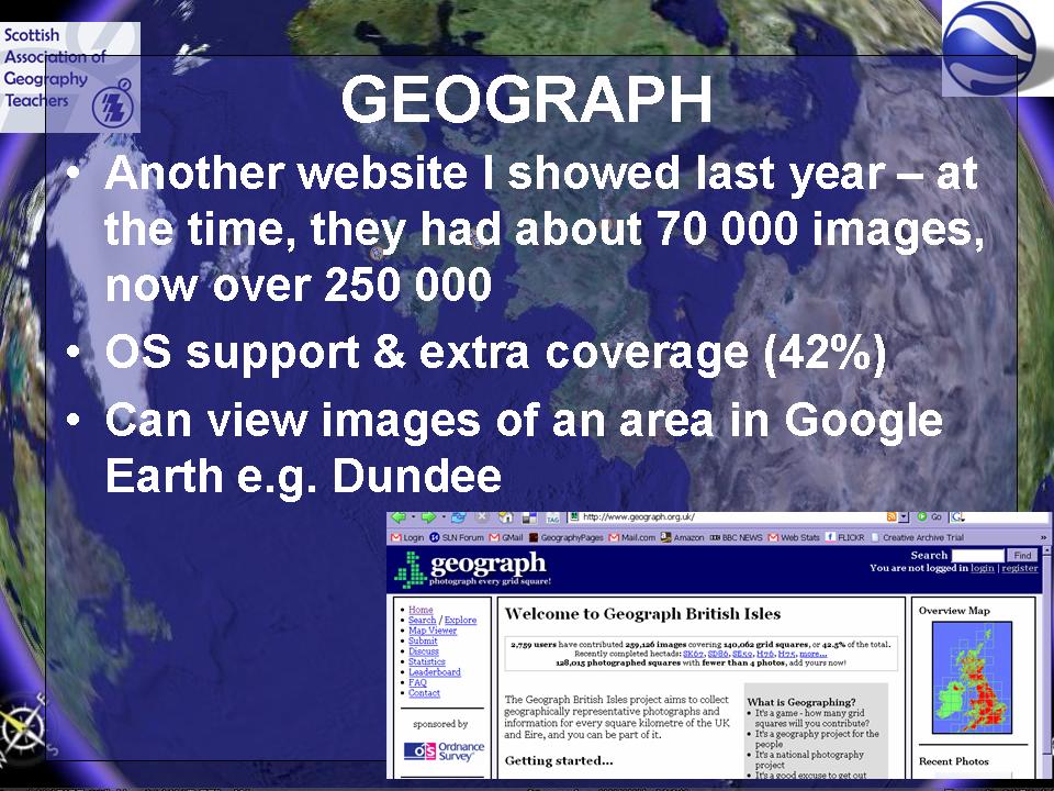
GEOGRAPH is one of my top ten most useful sites for Geographers. Fab images taken in context and viewable in Google Earth. Why not print off a checklist and go out and grab your local area.
GOOGLE EARTH RESOURCES FOR GEOGRAPHY TEACHERS
Updated October 2006
http://googlearthusersguide.blogspot.com/ - the new blog !!
LATEST NEWS
NEW VERSION 4 NOW AVAILABLE as of OCTOBER 2006, plus latest imagery updates and timeline animation feature
SKETCH UP - 3D MODEL MAKER for Google Earth - now a FREE DOWNLOAD (thanks to Noel J for the tip-off)
CHECK OUT GE GRAPH too for mapping fieldwork results (see later link)
GET INVOLVED IN THE 'MY PLACES' PROJECT NEW FOR SAGT CONFERENCE 2006 - check it out now !
http://www.gvisit.com/map.php?sid=c306540ba4c9a5cee016811e4b5c4c2c - can you see yourself ?
Also now available is PICASA 2 with WEB ALBUMS and GEOLOCATION on photographs. More on this soon.
Plus the GOOGLE EARTH AIRLINES website which has too much exciting stuff to mention - lots of ideas for making more of GE in the classroom...
http://www.kmzlinks.com/ - another great site I came across recently...
Had some exciting news on 17th October 2005. For the second time in three years I was awarded a Royal Geographical Society - Institute of British Geographers Innovative Geography Teaching Grant. This is to develop this area of the site, and produce a document in PDF form for downloading and a print version for distribution. This is to be called 'Earth: a User's Guide'
There is a chance for all of you to get involved too, as it's going to be a collaborative resource. Let me know:
how you use Google Earth
what would you like to know how to do ?
what are the best bits of Google Earth ?
where do you go ?
More to come soon. This is a fast changing arena. There are new ideas every day! I have had to adapt my original thinking as a definitive guide would be out of date the day after it was written. If you come across something interesting , let me know, by e-mailing me at geoblogs@[nospam]europe.com
Go to GOOGLE EARTH PAGE for downloading the NEW 13Mb file and more details. Once you have installed, and are running the BASIC Google Earth, you can upgrade to Google Earth PLUS for the princely sum of $20. There is also a PRO version, which is $400 (with a scheme underway to make it available free for a year to educators, although I am told by Dennis Reinhardt that there has been overwhelming interest, especially from the UK, so this offer has been temporarily suspended (as of September 2005 - could now be back on again)) The PRO version also has other modules which include a MOVIE MAKER, and also an opportunity to use GPS data. One (unofficial) estimate is that there have been over 12 million downloads of GOOGLE EARTH. I recommend that you download the PLUS version for the price, but bear in mind that this is a personal license, so there may be issues with using it in the classroom (which is not the case with the standard version)
Google Earth is a VIRTUAL GLOBE. There are others available.
GOOGLE EARTH RESOURCES FOR GEOGRAPHY TEACHERS
Google Earth Sites
Google Earth Hacks - has a useful forum and other leads to good finds. One of the first extras is a file of alternative PUSHPIN icons which could be used to mark a range of different features. Well done to Mickey for getting this off the ground so soon. This is a growing site, and has been referenced by many as one of the first of the wave of sites which set up to support users of Google Earth.
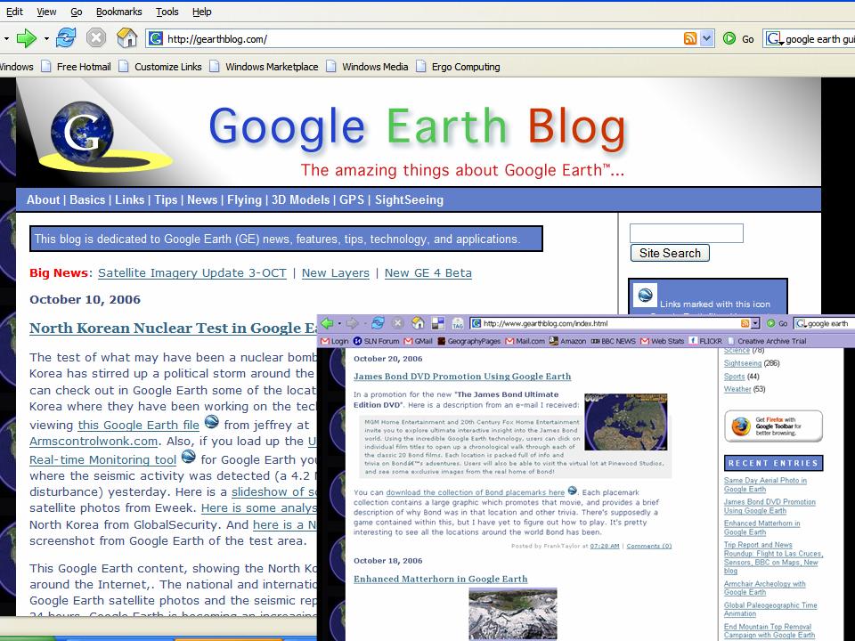
Some new materials are being added all the time to Frank Taylor's rather fine GEARTH BLOG, which is fast becoming THE essential GE bookmark.
Check out what's being added lately. This includes a good mention for GeographyPages and the Users Guide project. There is also a recent report on the Google Earth Developers Day which announced all sorts of exciting new updates.
New additions include a WIND FARM PUBLIC ENQUIRY resource which has to be seen to be believed, a MONTSERRAT teaching resource which is still hush hush and a recent success with Year 7 work related to the DIGITALLY DISTRIBUTED ENVIRONMENTS blog referred to elsewhere on this page. Also some good GE MOUSE MATS....
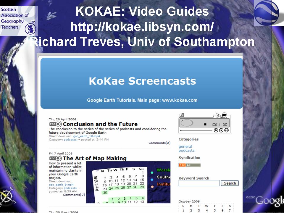
We've just started publishing a free weekly tutorial in using Google Earth, it would be particularly useful to teachers who want to use Google Earth in their lectures but aren't GIS (or IT for that matter) savvy. It would also serve as a resource for those who would like their students to produce something in Google Earth. The tutorials are screencasts (video tutorials with audio) of 5 minutes long, they are available in flash and quicktime format. There's other Google Earth related stuff on the site. Read the PRESS RELEASE for more. This has now also been referenced by GEarth Blog, and all the tutorials are now available to view.
Unusual and Interesting
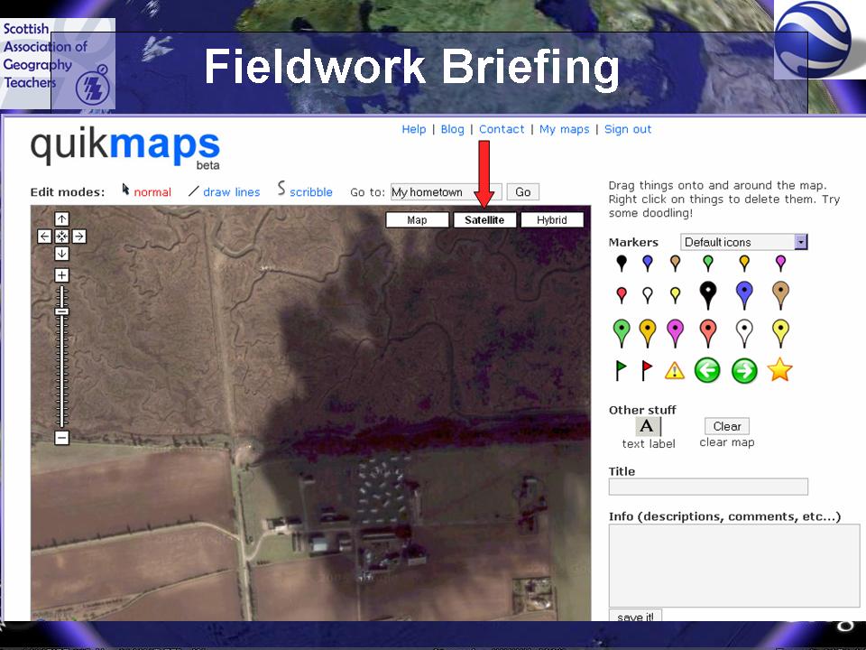
I recently used Google Earth to plan a trip to an INSET course and do the briefing, and risk assessment.
Tips for Classroom Use
1. Get GOOGLE EARTH... It's a quick download if you have Broadband (and a slow download if you haven't...) New version November 21st 2005
2. Update to GOOGLE EARTH PLUS or PRO (There is a scheme to provide a free PRO license for educational use but due to the tremendous interest in the offer - particularly from the UK - this has been suspended... In the meantime, you can have PRO OR PLUS free for 7 days.
3. Set a group of students the task of identifying key locations (perhaps with the aid of a Pearson Longman student atlas) and saving them for all to use as PLACEMARK FOLDER.
4. Make sure that you download the SIGHTSEEING TOURS from the main GOOGLE EARTH page.
5. Noel Jenkins posted a set of lesson resources relating to the use of GOOGLE EARTH in the classroom on his JUICY GEOGRAPHY site. This now includes a guide to using 3D buildings with GE Plus version, which costs just $20 to download. It involves creating polygons and then extruding them (sounds painful!) using a plug in from a site called SKETCH UP (this is now free as of April 2006)
6. Ollie Bray has been using Google Earth as a background on which to draw map symbols.
7. Noel Jenkins has created an excellent SAN FRANCISCO EARTHQUAKE exercise which is rather well executed and is worth exploring. It uses various techniques which will become more familiar to teachers over time. Recommended.
8. GOOGLE EARTH TOURING: http://www.googletouring.com/create.php A nice idea for a class activity, and which could also be given to a group of students to create. This could be an extension task for those students who have already done idea no. 3 above.
9. The data from GE can be saved as a file with a .KML extension. This allows users to save their data and share the data. There are also people working away to create scripts to post FLICKR images, GEOCACHES and other data. Some of those are listed in the table above. More details on this on the USERS GUIDE page.
10. SCALE: Give the impression of the size of physical and human features by positioning the cursor in the middle of / on the edge of your chosen feature and then set the view slowly scrolling along e.g. how big are cities, how long is a river ?
11. CROSS SECTIONS made easy. A full explanation is available from Tony Cassidy at RADICAL GEOGRAPHY. Saves all that messing around with strips of paper and graph paper. It is a bit fiddly mind..
12. Use the enthusiasm of the students - if they want to use it, let them use it ! They are expanding their Geographical literacy...
Google Earth was mentioned in the Evaluate supplement in the Education Guardian of 12/07/05 - the item mentioned a particular Geography teacher who used it in his lessons... http://www.ictadvice.org.uk/index.php?section=il&catcode=nwslttr_index&icttypeid=2&icteditionid=15&ictsectionid=&ictsubsectionid=&ictitemid=332
is a link to an article I wrote for the BECTa ICT ADVICE Newsletter in October 2005 on the subject of GOOGLE EARTH![]()
13. Get a FLICKR account now if you haven't got one, and upload photos (you can download up to 2Gb of photos per month)
14. CHECK OUT THE USERS GUIDE.... (Coming Autumn 2006)
There's one key aspect of Google Earth and that is the rapid pace at which it is changing. If you are looking at this page and thinking - 'he hasn't mentioned X' then please e-mail me and tell me about it...
There are now some new files and sites which you will find useful. Check out the SAGT PAGE for more details.
15. Also appear in a GIS booklet produced by the Advisory Group.
16. Watch out for the FUTURE FIELDWORK workshop of the GA SPC at the GA Conference 2007, which will feature Google Earth as well as other GIS.
17. Slides from my presentation at the SAGT Conference are now appearing at the weblog
GEOGRAPHY AND ALL THAT JAZZ...
"Share and enjoy..."
Douglas Adams
This site is not affiliated with Google. I just happen to think their products are great, and have enhanced my teaching for several years.


 Picasa Web Albums are a way of geolocating your images and viewing them in Google Earth. This is something worth investigating.