
Saturday, December 22, 2018
Thursday, December 13, 2018
Google Earth Studio
Just applied to have an invitation to this new tool for use with Google Earth.
Here's a video which may tell you more...
Here's a video which may tell you more...
Sunday, November 25, 2018
Saturday, November 24, 2018
The use of computers in the teaching of Geography
I've used this document in a few recent events, when I've been talking about technology in the Geography classroom. I wrote it as an assessment piece as part of my PGCE at the University of Hull 1986-7. There are large sections which are still relevant today, or which are a reminder of some of the 'dead ends' or challenges that still face those using technology in teaching.
Here's a slide clipped from the presentation I use, showing some of my own technology journey:

Please note that the original version had diagrams pritt-sticked onto it - this was the days before DTP was well established and available and I could only draw using standard characters. Those diagrams aren't available any more, but some could probably be located, along with some of the documents in the references.
The Use of Computers in the Teaching Geography by GeoBlogs on Scribd
Wednesday, November 07, 2018
Thursday, October 11, 2018
IAPS - GIS course
This course may be of interest to some readers of the blog.
IAPS Geography – Geographic Information System (GIS) for Prep Schools which is due to take place on Thursday 29 November 2018 at Abingdon School, Park Road, Abingdon, Oxfordshire OX14 1DE
The aim of this course is to make the purpose of GIS representation clearer for teaching Years 5, 6,7 and 8. Delegates will discover how simple GIS skills will help prepare pupils moving to senior schools have the relevant skills. Following an introduction to GIS, there will be practical sessions using the specialised computer room in Abingdon School’s Geography Department.
Delegates will take away new ideas on how they can use GIS in their geography lessons and how mapping and the use of GIS can enhance their pupils’ geographical knowledge and understanding.
Full programme and map is attached for your information.
For further details or to book online please visit https://iaps.uk/courses/detail/1341/
Friday, October 05, 2018
ArcGIS: a new free how-to guide
This free resource can be obtained from TES Resources.

We have created a new starter resource for ArcGIS Online - Developing knowledge, skills and confidence with ArcGIS Online. Its a PowerPoint with short how-to videos, good for teachers+students https://t.co/d5iCzbMTM2— Jason Sawle (@GIS4Schools) October 4, 2018
We hope its useful#geographyteacher #GIS #Edtech #free4schools pic.twitter.com/FSlv9GxOYs

Sunday, September 09, 2018
Project World
There are plenty of ways of seeing the world, and a growing range of tools which allow the user to explore map projections. Check out Project World. Remix the image in your browser and download it.


Sunday, August 26, 2018
Mr Williams' KML layers
Explore Earth's Aerosol - 08/23/2018 with @googleearth 4 web/mobile. GE file located in PhysicalGeography folder here https://t.co/ELyJQiWQuf #worldgeochat @EarthOutreach #EarthEdu #eartheveryday pic.twitter.com/ToIve4bof3— jwilliams (@geteach) August 26, 2018
Thanks for sharing these new layers for Google Earth.
Sunday, August 19, 2018
Thursday, August 16, 2018
OS GPS
As part of my GetOutside Champions work with the Ordnance Survey, I have the chance to do various exciting things. There are various outdoor events which the Ordnance Survey is represented at this year, such as Countryfile Live last week.
I've been sent an OS Trail model GPS to check out. This can be seen here.
The device has a rugged rubberised case, with finger grips moulded into it, making it easy and comfortable to hold. The screen is smaller than an iPhone or typical Android device, but is bright and clear.
The device needs to be connected to WiFi to set up (and download any updates) This was the first thing thing my device did, and it took a while to get up and running.
The touch screen is fairly responsive, although sometimes requires a slightly harder 'press' than a smartphone screen, although it is designed to be tougher, and water and dust resistant, and also to be seen in bright sunshine. The on-screen keyboard is a little small, and needs a little care to select the correct letter.
Battery life seemed to be very good and one charge lasted for quite a few days of light use.

Some users will be particularly requiring some of the additional features.
There is a feature which will guide rescuers to the device should there be a need to do that, which might give some users reassurance. This is called SeeMe - see details below.
Map tiles can be downloaded to a device using a free piece of software which needs to be downloaded for Mac or Windows.
A great option for those wanting a hand held GPS device.
I've been sent an OS Trail model GPS to check out. This can be seen here.
The device has a rugged rubberised case, with finger grips moulded into it, making it easy and comfortable to hold. The screen is smaller than an iPhone or typical Android device, but is bright and clear.
The device needs to be connected to WiFi to set up (and download any updates) This was the first thing thing my device did, and it took a while to get up and running.
The touch screen is fairly responsive, although sometimes requires a slightly harder 'press' than a smartphone screen, although it is designed to be tougher, and water and dust resistant, and also to be seen in bright sunshine. The on-screen keyboard is a little small, and needs a little care to select the correct letter.
Battery life seemed to be very good and one charge lasted for quite a few days of light use.
Some users will be particularly requiring some of the additional features.
There is a feature which will guide rescuers to the device should there be a need to do that, which might give some users reassurance. This is called SeeMe - see details below.
Map tiles can be downloaded to a device using a free piece of software which needs to be downloaded for Mac or Windows.
Trail also includes advanced features through FullConnect™, including Ant+™, Bluetooth® Smart, GPRS and Wi-Fi, so you can easily connect accessories and share your location and performance with friends in real-time.
You also get exclusive access to SeeMe along with a 6-month free subscription to get you started. Use SeeMe to broadcast your location with up to 20 people and share with them your routes and stats including distance, altitude, heart rate, power and more. You can also send your exact location via email and SMS should you get into trouble, with I.C.E (In Case of Emergency).
On top of all this, you get OS 1:250k base mapping for the whole of Great Britain, 6 x OS 1:25k free map tiles, a 6-month free subscription to SeeMe and a 3-year free subscription to our award-winning OS Maps.
A great option for those wanting a hand held GPS device.
Saturday, August 11, 2018
New OS Maps app feature
A new addition to the 3D flyover feature in the Ordnance Survey Maps app is now available to subscribers. Contours are visible when using the 3D features.
A further update which makes this an even more essential app for when you #GetOutside
A further update which makes this an even more essential app for when you #GetOutside
Sunday, August 05, 2018
Big Geography Litter Pick - using Survey123
 A new blog from Caiti Walter, has launched with an invitation to get involved in a Big Geog Litter Pick.
There are some additional tools for the Litter Pick project, which all teachers are invited to get involved with during August.
Open up the Survey123 Form that Katie Hall has completed, and you can enter your own findings.
#Geographyteacher alert! #TheBigGeogLitterPick2018 is live and happening throughout August! Find out more about how to take part here: https://t.co/V0MdyrZjpi— Caiti Walter (@EduCaiti) August 5, 2018
Quick guide -
Log your litter picks here: https://t.co/7QlXaHfH6e?
Keep an eye on progress here: https://t.co/FkI2htpqLS
Caiti's blog will share some ideas for sustainable teaching. As she says:
I was once told in my PGCE year, “Don’t sit with the moaners in the staff room, find the ‘yes’ people”. This blog aims to be that ‘yes’ person, not by patronising and pretending that all in teaching is rosy, but by simply highlighting the useful, inspirational, creative and funny outputs of a life in teaching.
Saturday, May 26, 2018
Mapping urban change
Another of the outcomes from the ESRI UK Annual Conference was awareness of the Urban Growth Explorer tool
This uses a swipe tool to explore the changes in the growth of key cities.

It's also worth remembering that there are some similar tools in Digimap for Schools - here's a short video explaining how that can work too...
This uses a swipe tool to explore the changes in the growth of key cities.

It's also worth remembering that there are some similar tools in Digimap for Schools - here's a short video explaining how that can work too...
Friday, May 11, 2018
Google Earth Tour Creator
A new tool from Google, which has been trialled by a few folks. It's the Tour Creator.
Apparently it's easy to make 3D tours from my computer, so let's see...
For an early look, and a link to some examples, Richard Treves has been quick off the mark, and posted here.

Apparently it's easy to make 3D tours from my computer, so let's see...
For an early look, and a link to some examples, Richard Treves has been quick off the mark, and posted here.

Monday, April 09, 2018
125 Top Geography Tips - plenty of GIS here...
 For the 125 days leading up to the conference, as part of the #125GA celebrations, there was a daily tweet offering a Top Tip for Geographers, with a tag #125geotips. These were on all sorts of geographical themes.
Thanks to the tens of thousands of people who read them and responded to them over on Twitter, but for those who don't use Twitter, here's all 125 collated for you. The hyperlink will take you through to the original tweet with all the relevant images and links to the resources.
Monday, February 19, 2018
GIS CPD
Details of a new option for GIS training were released earlier. Steve Richardson, who wrote quite a lot of the resources that are available on the ArcGIS Schools Resources section has organised a day looking at embedding GIS in the curriculum to support the progression of some key geographical skills and knowledge.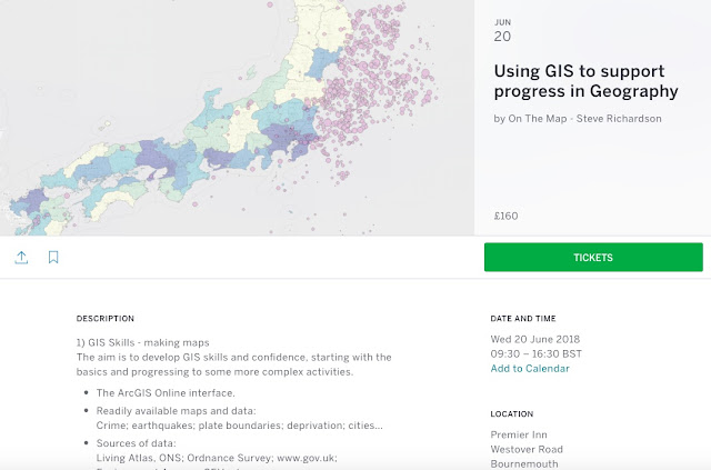
The price is £160 for the day, including lunch and refreshments and the first course is being run down on the South Coast in June.
More details here on the Eventbrite page.

The price is £160 for the day, including lunch and refreshments and the first course is being run down on the South Coast in June.
More details here on the Eventbrite page.
Sunday, February 18, 2018
Busting geographical misconceptions

Thanks to Simon Kuestenmacher on Twitter (follow him if you don't already) for the tipoff to this StoryMap.
As usual, scroll down to reveal the content.
Tuesday, January 30, 2018
Ordnance Survey #GetOutside Champions
This blog has a mapping focus, so here's my latest mapping related news...
Back from two days in the New Forest with Ordnance Survey. We were asked to come to Brockenhurst to a nice hotel, where we were to meet with the Ordnance Survey team that supports their core #GetOutside initiative. As you may remember from an earlier post, I applied to be involved for 2018/19 and was delighted to find out some weeks ago that I was going to be taking part, and also that Dan Raven Ellison, who applied independently, was also going to be going along.
A very early start and a long journey on 4 trains was needed, with Dan joining me in London.
Registration, coffee, and some chats to faces that I knew, including Sarah Outen.

Through to the main meeting room, where we were made very welcome and introduced to the scheme, and given new jackets and boots and various other things. We found out more about OS Maps, and the whole #GetOutside campaign.
We heard from previous and ongoing Champions, and also met Ben Fogle and Kenton Cool, who talked about their plans to climb Everest. Not something that most people can manage, and therefore my work will be far more down to earth, and even below sea level... with an educational emphasis.
We had a photo call: group and individual, and enjoyed some excellent food. In the afternoon, we were set a challenge, and I enjoyed working with the folks on my table: we were placed on a table for the day with other Champions, and some of the other partners involved. I had the chance to speak to Dave from Camping and Caravanning Club's membership magazine, and also Pip from 'Country Walking', which has been leading the #Walk1000miles campaign, which I've also blogged about previously.
We had a challenger treasure hunt to take part in, and we managed to cover the longest distance by running relays back and forwards for part of the time. Thanks to my team, who are pictured below, and there are also links to their twitter feeds for you to follow.

I'm also hatching up some plans with Dan Raven Ellison to connect our work with schools and young people, and the curriculum, and already have two schools in mind to visit...
Back from two days in the New Forest with Ordnance Survey. We were asked to come to Brockenhurst to a nice hotel, where we were to meet with the Ordnance Survey team that supports their core #GetOutside initiative. As you may remember from an earlier post, I applied to be involved for 2018/19 and was delighted to find out some weeks ago that I was going to be taking part, and also that Dan Raven Ellison, who applied independently, was also going to be going along.
A very early start and a long journey on 4 trains was needed, with Dan joining me in London.
Registration, coffee, and some chats to faces that I knew, including Sarah Outen.

Through to the main meeting room, where we were made very welcome and introduced to the scheme, and given new jackets and boots and various other things. We found out more about OS Maps, and the whole #GetOutside campaign.
We heard from previous and ongoing Champions, and also met Ben Fogle and Kenton Cool, who talked about their plans to climb Everest. Not something that most people can manage, and therefore my work will be far more down to earth, and even below sea level... with an educational emphasis.
We had a photo call: group and individual, and enjoyed some excellent food. In the afternoon, we were set a challenge, and I enjoyed working with the folks on my table: we were placed on a table for the day with other Champions, and some of the other partners involved. I had the chance to speak to Dave from Camping and Caravanning Club's membership magazine, and also Pip from 'Country Walking', which has been leading the #Walk1000miles campaign, which I've also blogged about previously.
We had a challenger treasure hunt to take part in, and we managed to cover the longest distance by running relays back and forwards for part of the time. Thanks to my team, who are pictured below, and there are also links to their twitter feeds for you to follow.
I'm looking forward to working over the coming year to encourage everyone to spend more time outside during 2018. It's certainly galvanised my own plans for getting outside more. In fact, when I finish this post I'm off out to the local common to get some pictures..."It's like an episode of The Apprentice, except everyone's nice" @OrdnanceSurvey #GetOutside Champion @PhillyByrde on the Great Champs Digital Scavenger Hunt 👌— Belinda Dixon (@BelDixon) January 25, 2018
Photo: @EatSleepCycle. Also featuring @jenandsim @GeoBlogs @sianannalewis and me 😎 #OSGO2018 #GetOutside pic.twitter.com/6I7QYgd6yV

I'm also hatching up some plans with Dan Raven Ellison to connect our work with schools and young people, and the curriculum, and already have two schools in mind to visit...
Wednesday, January 24, 2018
Digimap for Schools resource revamp

Over the last few years, I've written a number of Secondary resources to accompany the Digimap for Schools service. My colleague Paula Owens wrote a whole tranche of Primary resources too.
The resource area has now had a revamp so that it is easier to access particular resources from the archive.
— DigimapforSchools (@Digimap4Schools) January 22, 2018Big Splash! Our new Resources pages is now live! Lots of resources for Primary and Secondary.. we love it! come have a look.. https://t.co/VBWTyFmic4 #primary #secondary #PrimarySTEMchat #ukedchat #geographyteacher #STEM #digitalliteracy pic.twitter.com/YvU7vBL8Mz

The new look page can be accessed HERE.
It has resources for a range of subjects, not just geography, which is a reminder that if you are thinking of getting a subscription for your school, you should make a point that it is not just for geography, and have it paid from general budgets rather than your own budget...
Subscribe to:
Comments (Atom)