As part of the recent December update to the software, ArcGIS Online now has a range of new features, which are summarised here.
One of them is the addition of catchment area calculations, and also downstream channel plots.. Tried this out for a local river and it worked well...
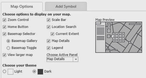
Also extra options for how maps are formatted for embedding on pages, and a new dark canvas basemap, which I like...
Here's a trial map of London
It's interesting timing given the withdrawal of the Google Earth API that one of the most interesting additions is the 3D Scene Viewer option.
Head here to find out more about it... one of my holiday plans is to get stuck into that and see what's possible...
A project originally funded by the Royal Geographical Society (with IBG) with an Innovative Geography Teaching Grant to develop teaching ideas for using Google Earth in the Geography classroom, expanded to include ArcGIS Online in 2014
Tuesday, December 16, 2014
Thursday, December 11, 2014
ArcGIS Online
A new update to ArcGIS Online has been released, and the details are here.
Some very interesting new features described here.
Here's a 3D resource, for example which shows Volcanoes and Earthquakes.
Looking forward to getting stuck in to this...
Some very interesting new features described here.
Here's a 3D resource, for example which shows Volcanoes and Earthquakes.
Looking forward to getting stuck in to this...
Tuesday, December 09, 2014
Wednesday, December 03, 2014
Subscribe to:
Posts (Atom)