Tuesday, February 06, 2007

E-mails

Got this e-mail today:
FROM Jeff Gomo.
Avenu 12 Rue 47 ABIDJAN
DANANI REFUGEE CAMP, ABIDJAN
REPUBLIC OF COTE-D'IVOIRE
Dear,
My name is jeff gomo and my sister, from Sierra Leone. My father and I escaped from our country at the heat of the civil war ,As a result of thepolitical instability in my country even after the war,
my father established his cocoa and coffee export business in Abidjan,Ivory Coast.He was in Buake, a northern city to negotiate for the purchase of a cocoaplantation when he was shot and killed by the rebel troupes fighting to takeover the government of the country on the 22nd September, 2002. The death of my father has now made me an orphan and thereby exposing me to danger.Beforethe unfortunate death, my late father had in his personal account with abank here the sum of $4.500m. As a result of the present insecurity of lives and property in this country,
I wish request that you assist me use youraccount in your country to transfer the balance of my father's account. Again to assist me with a letter of invitation that will make me get a visa to your country for residence inorder for me to continue our education and to invest the fund in a viable business venture.
I am willing to give you 20% while 5% has been earmarked for expenses. If this is acceptable to you, send me a mail through my regular e-mail account (gomo_jeff@yahoo.com) so that we can discuss further on this matter.
JEFF GOMO.

Anyone find this in Google Earth ?
I'm thinking of sending my bank details...

Friday, January 26, 2007

Amazing Touch Screen Interface

Frank Taylor over at Google Earth Blog posted about this amazing touch screen interface for using Google Earth (and other images / videos)
Watch and be amazed...

Wednesday, January 17, 2007

Ordnance Survey Mapping News

All schools should receive a copy of OS Mapping News twice a year.
The Winter 2006 issue (Issue 31) has just arrived and features a few items of interest for Google Earth users.
There is an article on using Google Earth Plus (an upgrade which costs just $20) and a GPS unit to create and map a historic trail on Cyprus.
There is also an article by Noel Jenkins relating to his San Francisco activity "Visualising a Safer City" which uses Google Earth to look at decision-making related to the location of a new building in the city.
It includes a file to download, and the article gives all the details for working through this tried and tested activity.
There are full details at the JUICY GEOGRAPHY page, from where I borrowed this Google Earth screenshot.
Thanks to Noel for mentioning my GeographyPages Users Guide at the end of the article!

Sunday, January 07, 2007

Google Earth Images

Meant to post about this a while ago, but just playing catch up.
Article in The Observer in November 2006 about how London is gaining an advantage over other cities in the UK (and exerting its primacy ?) because of the quality of images on Google Earth is much better in the capital than in other parts of the country.
London's images have up to date buildings whereas those in Liverpool, Birmingham, Manchester are still without...
In Liverpool, they reckon the images used were taken around 2001, whereas the new Arsenal stadium is visible in London. The Urbis centre is missing from Manchester for example, and neither is the new Bull Ring in Birmingham.
Google Earth spokesperson Rachel Whetstone said:
"We can only update things as soon as we have the data", and they rely on third party external companies for the data.
Keep an eye out for more updates to come.
Remember that Frank Taylor's GEARTHBLOG is probably the best place to look for news of these...

Saturday, January 06, 2007

Google Earth INSET Courses

Want some INSET on Google Earth ?

The RGS-IBG are offering a full day course looking at using Google Earth to create a Virtual fieldtrip by adding digital content. It's on the 22nd of January, and further details are available on the RGS website. School members should also have been sent flyers. The course is being run by Jamie Buchanan Dunlop and will involve fieldwork in Hyde Park. It costs a very reasonable £30.

Noel Jenkins is also running a course in London on June the 28th. Details are already posted on DIGITAL GEOGRAPHY.

There are also some useful tips at the GE LESSONS website.

Monday, January 01, 2007

Happy New Year to all my readers!

Currently listening again to the Radio 4 Today programme on listen again, which was edited by the G Team.
Interesting clip from Vanessa Lawrence on the importance of maps in our everyday lives:
"there is more geography being used today than ever before" OS provide the data for Google Maps.

Also item on the connection between immigration in Britain and the effect on poverty in Africa.
Apparently people of African origin send home an average of just under £1000 a year. Interview with some Ghanaians living in London and from correspondent in Ghana.

An item on the growth of the EU: the link between Europe and links between Europe.

My Walks: project from Northumbria University - look at familiar places as an unfamiliar place. Geography is about change in the contemporary world. Interview with Dr. Duncan Fuller from the university.

Final interview with the guest editors.

Doreen Massey provided a small input relating climate change to globalisation. We demand goods but don't take responsibility for the carbon emissions produced by their production and transportation. We will meet our Kyoto protocol targets because of the change in our economy and this has "reshaped the Geography of the UK itself..." as our economy revolves around London and its financial sector.

Congratulations to Dan, David and Hannah - a job very well done!

Dan talked about his geograpical teaching. Geography sits centrally in the curriculum...
Creates a real meaning and purpose to the curriculum...

David talked about the importance of fieldwork: the basis of which is observing: using your eyes.

Dan talked about how issues tend to be separated by the media rather than brought together using Geography.

Wednesday, December 20, 2006

Share your Ideas and KMZs...

There's a lot of geographers out there using Google Earth in interesting ways.
Why not share your ideas, and move towards being a COLLABORATOR rather than an ISOLATOR.
Thanks to Quentin d'Souza for allowing use of his image below. Which one most describes your practice and what can you do to move to the left ?

Tuesday, December 19, 2006

Google Earth and NASA

Ollie Bray made me aware of this via Boing Boing (getting hard these days to establish who does things first...) which is apparently the completion of something announced a while ago.
NASA are teaming up with Google Earth (and the National Geographic) to release NASA data in areas such as weather forecasting...
Could be useful for Geographers. I'll keep an eye out for more...

Thursday, December 14, 2006

ViaTime

This post seems to have come out blank.
It was telling you about a virtual transportation simulator where you can set up an airline and see the routes in Google Earth.
Check out VIATIME for more. I'll try and have a play over Xmas.

Sunday, December 10, 2006

Cambridge in 3D & Icelandic Posters

The first part of post comes via DIRECTIONS MAGAZINE and the Keyhole BULLETIN BOARD and OGLE EARTH. Thanks to all for the link.

Below is a general view looking down on Cambridge. Great work by Lattico, to add 3D Modelling - be warned though that this is a large file, and could take some time to load !
This will come in useful for us, as we take our 6th formers to Cambridge for a Human field day, and this will make our Virtual walk through even more lifelike. We use Google Earth for fieldtrip briefings.

Another find via Ogle Earth today was an interesting merging of two technologies I've used separately, but hadn't thought about putting together before. This is the work of Mr. Fjalar from Breidholt in Iceland, who has called his project ARTWORK EARTH. This is a rather nice idea which I may well borrow for an end of term project, or link in at the end of a unit of physical work such as COASTS, RIVERS, GLACIATION, VOLCANOES & EARTHQUAKES or NATURAL ENVIRONMENTS/BIOMES.Students are asked to find an image which looks particularly impressive artistically, perhaps like the one above, and save it - by screenshotting, or otherwise..

The images are then put into John Watson's superb BIG HUGE LABS' FLICKR TOYS site, which is one of my Top 5 sites of all time as those who are regular visitors to the website will know. (incidentally, having visited this today there's a new Warholizer which will make Warhol screenprint images out of your photos...)

The images are put into the MOTIVATOR tool, and then uploaded to the FLICKR POOL which this links to: ARTWORK EARTH.

Already this has been picked up and developed by others. This TAGZANIA post for example suggests using this idea to produce CHRISTMAS CARDS. I've already sent mine, or I might have used this idea myself...

And finally for this post, because I really have to get on to my marking...

Don't forget that if you're using Google Earth for a research project, you can use TOOLS and WEB to open a web browser window below the Google Earth view (or press CTRL and 8)
Might be a useful tip for some of you...

New Geographic Layers


Thanks to Frank Taylor at GEarth Blog for flagging up a new Geographic Layer option for Google Earth. This is a layer which needs to be turned on, but will then display Geographic content which increases as you zoom in. Worth investigating...

Saturday, December 09, 2006

Planet Earth and Wiki Find

One of my other blogs was nominated for an Edublogs Award 2006 - I know because it was me that nominated me...
Unfortunately, I was passed over, but when I checked on the blogs that had been nominated I came across CLASSROOM GOOGLE EARTH Wiki.
There are some useful ideas for using Google Earth, and a recent posting led me to some High Definition Video Clips from the Planet Earth series.
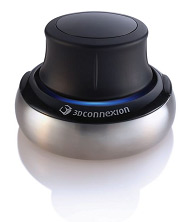
Some useful Geography content here.Enjoying my Space Navigator - it's responsive and I'm getting the hang of the various axes of movement that are available. I love the ability to zoom right into details on images as well, which works very well on the IWB. Get one for Christmas! You can order one from 3D Connexion, delivery is very prompt.

Tuesday, December 05, 2006

Mystery Place and Space Navigator

Discovered this place today while flying around Google Earth with my Space Navigator.
Have been exploring the settings, and getting used to it....

UPDATE: The island is called CHRISTMAS ISLAND of course...

Sunday, December 03, 2006

Sky News and Glaciers

Google Earth just been used by Sky News to zoom in to the location of a breaking news story.

Quite a few news networks are using Google Earth as a visual means of locating the news story they are reporting on.

Thanks to Noel Jenkins for flagging up a file mentioned on GEarth Blog which plots glaciers and whether they are advancing or retreating. Will be very useful !

Saturday, December 02, 2006

Space Navigator and Google Earth in the papers

OK, so my Space Navigator is here, and I've installed it on my laptop and enjoyed zooming in and out of images and flying around the screen.
Will wait until Monday to try it with Google Earth at school (yes Noel, I'll show it at my Department meeting on Monday, and probably play about in my lessons too...)

Google Earth in the paper (The Times) today. There was an article explaining how it has been used in elections in Bahrain to show the opulent dwellings of the ruling family to try to sway public opinion. There was also a report on Google Sight Seeing. This has a section on the Top 10 naked people on Google Earth. You could use your Space Navigator to speed up exploration of this list...
Why not buy a copy. Click the Amazon link below to head there and buy a copy (or two - it's coming up for Christmas!)
In Association with Amazon.co.uk
Just noticed this is an old referral button. You only have to spend £15 now to get Free P&P.